Somerset, Vermont
Somerset, Vermont | |
|---|---|
Town | |
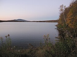
 Somerset Reservoir, Somerset, Vermont | |
 Located in Windham County, Vermont | |
 Location of Vermont with the U.S. | |
| Coordinates: 42°58′00″N 72°58′00″W / 42.96667°N 72.96667°W | |
| Country | United States |
| State | Vermont |
| County | Windham |
| Chartered | 1761 (Vermont) |
| Elevation | 2,000 ft (610 m) |
| Population (2020) | |
• Total | 6 |
| • Density | .2/sq mi (0.08/km2) |
| Time zone | UTC-5 (EST) |
| • Summer (DST) | UTC-4 (EDT) |
| ZIP Code | 05360 (Stratton) |
| Area code | 802 |
Somerset is an unincorporated town in Windham County, Vermont, United States. As of the 2020 census, it had a total population of 6.[1] Somerset is one of five unincorporated towns in Vermont, having been disincorporated in 1937. The town has no local government and the town's affairs are handled by a state-appointed supervisor.
Geography
[edit]According to the United States Census Bureau, the town had a total area of 28.1 square miles (72.9 km2), of which 26.1 square miles (67.7 km2) is land and 2.0 square miles (5.2 km2) is water. The total area is 7.07% water. It is located high in the southern Green Mountains, with its little habitable terrain sandwiched between the main spine of those mountains and Mount Snow.
Demographics
[edit]| Census | Pop. | Note | %± |
|---|---|---|---|
| 1790 | 111 | — | |
| 1800 | 130 | 17.1% | |
| 1810 | 199 | 53.1% | |
| 1820 | 173 | −13.1% | |
| 1830 | 245 | 41.6% | |
| 1840 | 262 | 6.9% | |
| 1850 | 321 | 22.5% | |
| 1860 | 105 | −67.3% | |
| 1870 | 80 | −23.8% | |
| 1880 | 67 | −16.2% | |
| 1890 | 61 | −9.0% | |
| 1900 | 67 | 9.8% | |
| 1910 | 27 | −59.7% | |
| 1920 | 59 | 118.5% | |
| 1930 | 20 | −66.1% | |
| 1940 | 5 | −75.0% | |
| 1950 | 8 | 60.0% | |
| 1960 | 4 | −50.0% | |
| 1980 | 2 | — | |
| 1990 | 2 | 0.0% | |
| 2000 | 5 | 150.0% | |
| 2010 | 3 | −40.0% | |
| 2020 | 6 | 100.0% | |
| U.S. Decennial Census[2] | |||
At the 2000 census there were 5 people, 2 households, and 1 family residing in the town. The population density was 0.2 people per square mile (0.1/km2). There were 28 housing units at an average density of 1.1 per square mile (0.4/km2). The racial makeup of the town was 100.00% White.[3] Of the 2 households 50.0% had children under the age of 18 living with them, 50.0% were married couples living together, and 50.0% were non-families. 50.0% of households were one person who were 65 or older. The average household size was 2.50 and the average family size was 4.00.
The age distribution was 40.0% under the age of 18, 40.0% from 25 to 44, and 20.0% who are 45 to 64 years old. The median age was 34 years. For every 100 females, there were 400.0 males. For every 100 females age 18 and over, there were 200.0 males.
Christmas tree
[edit]In 2007, the Capitol Christmas Tree was cut from the Green Mountain National Forest in Somerset.[1]
Snow
[edit]On March 5, 1947, Somerset had 78 inches (200 cm) of snow on the ground, the greatest daily snow depth for any location anywhere in Vermont.[4]
Notable people
[edit]- Elbridge Boyden, noted Worcester architect
- Lyman Enos Knapp, governor of the District of Alaska (1889 to 1893)
References
[edit]- ^ "Census - Geography Profile: Somerset town, Windham County, Vermont". Retrieved January 6, 2022.
- ^ "U.S. Decennial Census". United States Census Bureau. Retrieved May 16, 2015.
- ^ "U.S. Census website". United States Census Bureau. Retrieved January 31, 2008.
- ^ "Vermont Snowfall and Snow Depth Extremes Table". National Climatic Data Center. National Oceanic and Atmospheric Administration. Retrieved February 9, 2013.
External links
[edit] Media related to Somerset, Vermont at Wikimedia Commons
- Virtual Vermont

